Is Garmin Gpsmap 67I Worth It? Honest Review & Buyer’s Guide
Is Garmin Gpsmap 67i Worth It?
If you love exploring the outdoors, you know how important reliable navigation and communication are. Getting lost or losing signal in remote areas can be dangerous. Devices like the Garmin GPSMAP 67i promise both navigation and satellite messaging, making them popular with hikers, campers, and adventurers. But is this device really worth the price? Let’s dive deep into its features, real-world performance, and how it compares to other options, so you can decide if the GPSMAP 67i is the right choice for you.
What Is The Garmin Gpsmap 67i?
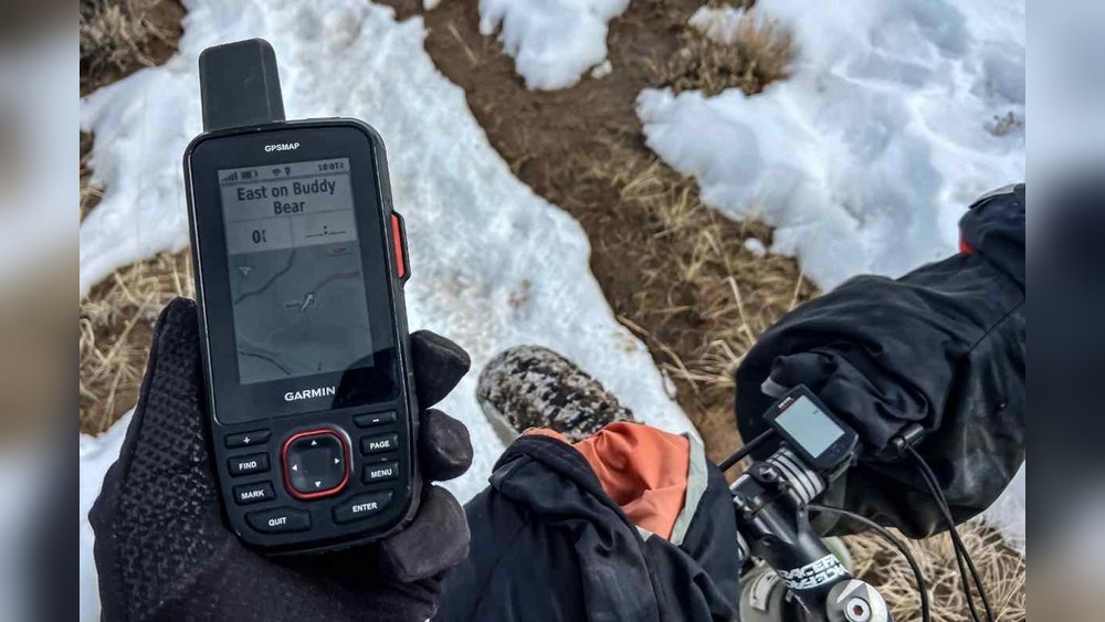
The Garmin GPSMAP 67i is a handheld GPS device with built-in satellite communication. It combines detailed mapping with the ability to send and receive messages almost anywhere in the world, thanks to Iridium satellite network coverage. This is more than a simple GPS—it’s a lifeline for those who venture far from cell towers.
The device offers:
- High-accuracy GPS tracking
- Off-grid messaging (send/receive texts)
- SOS emergency alerts
- Rugged design for harsh environments
With its long battery life and advanced mapping, the GPSMAP 67i targets people who need reliability and communication in the wilderness.
Key Features And Specifications
The GPSMAP 67i stands out from other GPS units due to its mix of navigation and communication. Here’s a breakdown of what you get:
Navigation
- Multi-GNSS Support: Uses GPS, GLONASS, Galileo for strong satellite coverage.
- Preloaded Topo Maps: Includes detailed maps of North America, with options for global mapping.
- Track Recording: Stores your route, waypoints, and locations.
- Barometric Altimeter: Measures elevation changes.
- Compass: Digital compass, works even when standing still.
Communication
- InReach Technology: Two-way messaging via satellites. No cell signal needed.
- SOS Button: Sends emergency alerts to a monitoring center, 24/7.
- Location Sharing: Lets friends or family follow your journey online.
Hardware
- Rugged Build: Waterproof (IPX7), shock-resistant.
- Battery Life: Up to 165 hours with tracking on; up to 30 days in expedition mode.
- Display: 2.7-inch color screen, easy to read in sunlight.
Other Features
- Bluetooth and Wi-Fi: For syncing with the Garmin Explore app.
- MicroSD Slot: Expandable storage for extra maps.
- USB-C Charging: Faster and more modern than older Garmin devices.

Real-world Performance
A device may look good on paper, but the true value comes from actual use. The GPSMAP 67i performs well in difficult conditions:
- Satellite Lock Speed: Acquires position quickly, even under tree cover.
- Message Reliability: Messages usually send within 2-5 minutes, even in remote valleys.
- Durability: Survives drops, rain, snow, and extreme temperatures.
- Battery: Lasts through multi-day trips without charging, especially in expedition mode.
Some users report that navigation is easy, with clear directions and accurate mapping. The SOS feature has saved lives, especially in cases where hikers were injured and out of cell range.
How Does The Gpsmap 67i Compare To Other Devices?
Choosing a GPS device means comparing it with alternatives. The GPSMAP 67i isn’t the only option—let’s see how it stacks up.
Garmin Gpsmap 67i Vs. Garmin Gpsmap 66i
Both devices are similar, but the 67i is newer and has improvements.
| Feature | GPSMAP 67i | GPSMAP 66i |
|---|---|---|
| Battery Life (Tracking) | Up to 165 hrs | Up to 35 hrs |
| Charging | USB-C | Micro USB |
| GNSS Support | GPS, GLONASS, Galileo | GPS, GLONASS, Galileo |
| Mapping | TopoActive, BirdsEye | TopoActive, BirdsEye |
| Messaging | inReach | inReach |
The main advantages of the 67i are much longer battery life and USB-C charging. This matters for longer trips and future-proofing.
Garmin Gpsmap 67i Vs. Garmin Inreach Mini 2
The inReach Mini 2 is smaller and cheaper, but lacks advanced mapping.
| Feature | GPSMAP 67i | inReach Mini 2 |
|---|---|---|
| Size | Large handheld | Pocket-sized |
| Mapping | Full maps | Basic navigation |
| Messaging | inReach | inReach |
| Battery | Up to 165 hrs | Up to 14 days |
| Price | Higher | Lower |
If you want advanced navigation and a bigger screen, the GPSMAP 67i is better. The Mini 2 is good for those who want messaging but don’t need maps.
Gpsmap 67i Vs. Smartphone Apps
Many hikers use apps like Gaia GPS or AllTrails. These are cheaper but need a phone and often a cell signal.
| Feature | GPSMAP 67i | Smartphone Apps |
|---|---|---|
| Satellite Messaging | Yes | No |
| Offline Maps | Yes | Sometimes |
| Battery Life | Up to 165 hrs | Varies (often less) |
| Durability | Very high | Low |
| SOS Function | Yes | No |
Smartphones are more fragile, run out of battery quickly, and don’t offer satellite messaging or SOS. For serious trips, the GPSMAP 67i is safer.

Pricing And Value
The GPSMAP 67i is not cheap. As of mid-2026, it costs about $600 USD. You also need a monthly subscription for satellite messaging, ranging from $12 to $50 depending on your plan.
Is it worth the price? For day hikers or those who stay near cell service, it might be overkill. But for remote explorers, the value comes from:
- Safety: SOS feature could save your life.
- Peace of Mind: Stay in touch with family.
- Navigation: High-quality maps and tracking.
If you travel far from civilization, the cost is justified. For casual users, less expensive devices or smartphone apps are probably enough.
Who Should Buy The Garmin Gpsmap 67i?
The GPSMAP 67i is best for:
- Backcountry hikers
- Hunters
- Mountaineers
- Long-distance cyclists
- Boaters
- Search and rescue teams
Anyone who goes into areas without cell coverage and needs both navigation and communication. If you’re only hiking in city parks, it’s more than you need.
Not For Everyone
Beginners often think they need the most advanced gear. But the GPSMAP 67i is a specialist tool. If you only hike a few times a year, or always have cell service, you can save money with simpler devices.
Hidden Insights And Tips
Most reviews focus on the obvious features. Here are some less-known points:
- Battery Saving Tricks: Expedition mode is not just marketing—it reduces tracking intervals and disables some features to extend battery. For multi-week trips, this is critical.
- Weather Alerts: The GPSMAP 67i can receive weather forecasts via satellite. Many users miss this, but it’s a big help for safety.
- Message Size and Speed: Shorter messages send faster via satellite. If you need urgent communication, keep texts brief.
- Navigation Without Cell Signal: Download extra maps before your trip. The GPSMAP 67i can store a lot, but you must prepare ahead.
- Subscription Pausing: If you only use the device a few times a year, you can pause your inReach subscription, saving money between trips.
These tips can make a big difference in real-world use.
Common Mistakes To Avoid
New buyers often make mistakes that reduce the value of their device:
- Not learning the interface: The GPSMAP 67i has many features. Take time to practice before your trip.
- Forgetting to charge: Always start with a full battery. Expedition mode can help, but nothing replaces a good charge.
- Ignoring map updates: Outdated maps can cause problems. Update before each trip.
- Misunderstanding subscription plans: Some plans limit messages or tracking. Check details to avoid surprise charges.
- Not carrying backup power: Even with long battery life, a small power bank is wise.
Avoiding these mistakes ensures you get the most from your investment.
User Experience: Real Stories
Many users have shared their experiences online. Here are a few examples:
- Sarah, a mountain guide: She relies on the GPSMAP 67i for guiding groups in the Rockies. The SOS and messaging features let her stay in touch with base camp, and the battery lasts for week-long trips.
- Tom, a hunter: He uses the device to mark hunting spots and send check-in messages to family. He says the device survived rain, mud, and drops without issue.
- Emily, a solo hiker: She triggered the SOS after breaking her leg in a remote area. Rescue teams found her using her GPS location within hours. She credits the device with saving her life.
These stories show the real value of the GPSMAP 67i—peace of mind, safety, and reliable navigation.
How To Set Up And Use The Gpsmap 67i
If you buy the GPSMAP 67i, setting it up properly is important. Here’s a simple guide:
- Charge the device fully before your first trip.
- Set up your inReach account online. Choose a subscription plan.
- Download maps for your planned area.
- Sync with Garmin Explore app for easy route planning.
- Test messaging and SOS functions in a safe area.
- Configure tracking intervals—shorter intervals for precise tracking, longer for battery savings.
- Input emergency contacts for SOS alerts.
Many users skip steps 5 and 7, but testing features before your trip prevents problems. Always practice using the device so you’re not learning during an emergency.

Safety And Emergency Use
The SOS feature is a major reason to buy this device. When you press the SOS button, you contact a 24/7 monitoring center. They coordinate rescue and provide updates.
- Accuracy: The device sends your GPS location to rescuers.
- Communication: You can exchange messages with the center to explain your situation.
- Global coverage: Works almost anywhere, even Antarctica.
Some emergencies need quick action. The GPSMAP 67i is designed for fast response, but you must keep it accessible and powered.
Is The Garmin Gpsmap 67i Worth It?
Let’s answer the main question. For most people who explore remote areas, the GPSMAP 67i is worth it. It combines navigation, communication, and emergency support in one tough device. The price is high, but so are the benefits.
If you only hike in urban parks or don’t need satellite messaging, it’s more than you need. But if you value safety, peace of mind, and reliable navigation, this device is hard to beat.
One extra insight: Many users say the mental comfort of knowing you can call for help is priceless. Even if you never use the SOS, the device lowers stress and lets you focus on enjoying your adventure.
For those who want the most current specs and pricing, check the official Garmin website: Garmin GPSMAP 67i.
Frequently Asked Questions
What Is The Battery Life Of The Garmin Gpsmap 67i?
The GPSMAP 67i lasts up to 165 hours with tracking on, and up to 30 days in expedition mode. Real-world use depends on settings, messaging, and weather. Always carry a backup power source for long trips.
Does The Gpsmap 67i Work Everywhere?
Yes, the device uses the Iridium satellite network, which covers almost all of the planet, including oceans and polar regions. Some deep caves or thick forests may reduce signal, but overall coverage is excellent.
Can I Use The Gpsmap 67i Without A Subscription?
You can use the navigation and mapping features without a subscription. However, satellite messaging and SOS require an active inReach plan. You can pause your subscription between trips to save money.
Is The Gpsmap 67i Waterproof?
Yes, it has an IPX7 rating, meaning it can handle rain, splashes, and brief immersion in water. It’s built to withstand rough outdoor use, but avoid deep underwater use or saltwater exposure.
How Do I Update Maps On The Gpsmap 67i?
Connect the device to your computer or Wi-Fi and use the Garmin Express software or Garmin Explore app to download new maps. Updating before every trip ensures you have the latest trails and topography.
The Garmin GPSMAP 67i is a powerful tool for outdoor adventure. For those who need both navigation and satellite communication, it offers unmatched safety, reliability, and peace of mind. If your trips take you far from civilization, it’s a wise investment.
If you stay local, simpler options may suit you better. The right device can make all the difference—choose based on your real needs, not just marketing.